arrow pointing right arrow pointing left

Location

number two
North Canyon
River Mile 20.7

Grand Canyon Time Machine

John Wesley Powell led the first science expedition, one-armed, down the Colorado River and into the Grand Canyon in 1869, before the dam, when the water was more unpredictable and he was making the first map of the place. Our group of UC Davis students is retracing his journey — except it’s totally different.

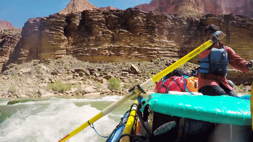
Powell’s crew had to row unwieldy wooden dories backward down the river, “reading” the texture of the rocks to gauge danger up ahead. “In softer strata, we have a quiet river, in harder we find rapids and falls,” he wrote. He lost three of his men along the length of river the two halves of our group will cover in the next 20 days.

But our boats are big, inflatable rafts that are fairly sturdy, especially when loaded down with our gear. The river, though still dangerous at times, is now more predictable post-dam. And while this geology-heavy group probably could read the strata for warning signs, waterproof maps on each boat spell out in detail tricky points, the intensity of upcoming rapids and tips for handling them. Another advantage: Many of the guides have taken this trip multiple times.

River guides rock

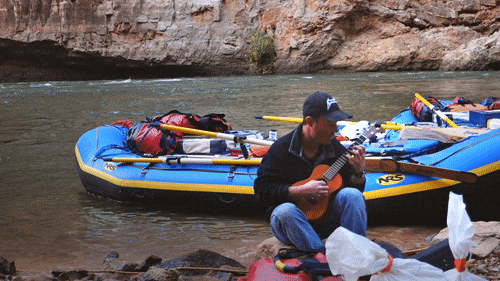
We all quickly learn that the guides are the real rock stars of this trip. We are putting our lives in their hands, and their easy grins belie the seriousness with which they take their responsibilities.

One of the guides, UC Davis alum Avi Patil, puts me particularly at ease. He’s a naturally calming person who’s rafted through the Grand Canyon seven times—four of them as a guide with UC Davis’ Campus Recreation and Unions’ Outdoor Adventures. The cherry on top is he’s also a Stanford physician and professor of emergency medicine. At one point, he served as the Dalai Lama’s personal physician when His Holiness would visit the United States. (If he’s good enough for the Dalai Lama, he’s good enough for me, I figure.)

A trip guide paddles around a dangerouse obstacle on the Colorado River
One of the guides, UC Davis alum Avi Patil, makes an effortless turn around a boulder to keep the team afloat. Credit: UC Davis

He also coordinates medical evacuations for an adventure racing company, the kind people sign on with to run up Mount Kilimanjaro or across the Sahara Desert.

“Avi’s not really the guy you go to for a Band-Aid,” class instructor Carson Jeffres tells me before the trip. “He’s who you go to if you need your arm stitched back on in the middle of nowhere.”

As Avi rows along the river, he looks entirely content. Here’s someone who has traveled to the planet’s most remote, beautiful places, and yet he says unprompted: “This is the best trip ever. Anywhere.”

To best experience 360° videos on a desktop computer, do not use the Safari browser. To view on mobile devices, install the YouTube app on your phone or tablet.

Grand Outdoor Adventures

Then there’s Jordy Margid, who leads Campus Recreation and Unions’ Outdoor Adventures and is head organizer for this trip. If we are safe, well-fed, have a way to use the bathroom, and are all present and accounted for, that’s thanks largely to Jordy’s direction. He’s run the Colorado River through the Grand Canyon 14 times, six of which were while guiding this class trip. He’s one of two kayakers who run with the rafts at all times, just in case quick and nimble action is required on the river. He looks most at home when paddling his kayak against a rapid and doesn’t seem to feel temperature like the rest of us.

A man plays a ukelele on the shores of the Colorado River
Lead guide Jordy Margid takes a ukulele break along the Colorado River. Credit: Joe Proudman/UC Davis

“Jordy could walk barefoot in the snow and not notice that it’s cold,” Cathryn Lawrence, assistant director of the UC Davis Center for Watershed Sciences, tells me before the trip.

He goes shirtless and wears flip-flops while the rest of us are geared to the hilt in wet suits or dry suits and neoprene socks. We slowly watch his skin go from white to roasted lobster over the coming days.

First major rapid: House Rock

Nevertheless, for all this expert guidance, I’m nervous as we approach our first major rapid around mile 17, House Rock.

Before we can see it, we hear it. A soft dragon’s roar of water that gets louder and louder as we inch forward. I’m pretty sure my palms are sweating, but they’re wet, so who knows? Some in the group are giddy at the idea of some wet, stupid fun. But I’m new to this whitewater stuff and not a thrill-seeker by nature.

I think about death — and hitting my head on rocks — and flipping our boat and being stuck underneath it — and being sucked underwater and… you get the idea.

So as we slip down the V-shaped tongue of the river and into the first choppy waves, I grip the boat’s rope handle in front of me. My heart pounds as we drop into our first wave. Then I can’t help but smile and whoop like a kid on a roller coaster just like everyone else going over this rapid. It’s a blast.

History unfolds rock layer by rock layer in the Grand Canyon for UC Davis students rafting the Colorado River. Photo: Joe Proudman/UC Davis

Time travel on the Colorado River

To explore the canyon by river is to be in a constant state of awe — not just of the Grand Canyon’s beauty, but also of the unrelenting, overwhelming sense of time these rocks expose to us, mile after mile. Like a living natural history museum, each section tells a new chapter of Earth’s life story. 

My boat mate as we head to North Canyon for our first big hike of the trip is geology graduate student Michael Kenney. He explains that we’re going deeper into time as we continue our trip down the river.  

The cliffs around us are made up of distinct sections, like layers of a cake stacked on top of each other, each with its own name. With the geology students, it’s almost a game — “Name that Strata” — to see who can identify the next rock layer first.

A man points at the canyon walls in front of a seated group
Graduate student Michael Kenney describes the various layers of the Grand Canyon’s walls, which represent millions of years. Photo: Joe Proudman/UC Davis

Michael points out the reddish Hermit Shale, formed about 280 million years ago in what was then a sandy river floodplain. Topping it is yellowish-white Coconino sandstone, made in a Sahara-like environment. The Toroweap and Kaibab layers preserve marine fossils born when this was a sea. And topping it off is the Moenkopi layer, formed when the earth here was a riverbank where dinosaurs roamed.

We’re looking at a time span of about 40 million years, and these are the “young” rocks. By the end of our trip at Bright Angel Trail, we’ll have traveled through nearly 2 billion years of geologic time.

Riverside view of the history of the world

It’s all rather mind-boggling. How can anyone truly absorb the magnitude and weight of time in the Grand Canyon? Here we are in a raft, looking at the history of the world. Beneath our feet and above our heads, dinosaurs lived and died; tropical sea creatures thrived; mass extinctions took place; desert replaced ocean; the Earth quaked; volcanoes erupted; ancient civilizations hunted, made baskets, stored grain and ate breakfast. And we traveled in a boat.

“You get an aspect of deep time here that you don’t get in other places,” Michael tells me. “A lot of times, you can put your hands between two rock layers and know a lot of time has passed. But here you can see an entire era of geologic time.”

Soil biochemistry grad student Toby Maxwell describes how plants can grow out of what seems like nothing in North Canyon. Credit: Toby Maxwell/UC Davis
“It’s like being in an interpretive exhibit. You just point at something interesting and say, ‘What?'”' or ‘Why?', and somebody knows.” – Mateo Robbins, environmental policy graduate student

North Canyon hike

Somewhere, a canyon wren sings its falling song, as if Pac-Man was just eaten by a ghost. Feet crunch on trail. A student nods at a rock and says, “Nice conglomerate.”

As we hike to North Canyon, necks arch upward and around to see mocha brown walls with swirling patterns. They look as if someone placed their palm on once-wet mud and waved it back and forth.  Except these patterns weren’t formed by anyone’s hand, or even wind or water.

“Plumose structures!” exclaims Veronica Prush, a bright and passionate geology student. She stops for a minute and explains that these featherlike patterns record the direction a rock broke when it was forcibly snapped apart under pressure.

Veronica’s impromptu mini lecture is a great example of what environmental policy graduate student Mateo Robbins says later on the boat about this group: “It’s like being immersed in an interpretive exhibit — you just point at something interesting and say ‘What?’ or ‘Why?’ and somebody knows.”

Geology graduate student Veronica Prush describes “plumose structures” on the walls of North Canyon. Credit: Veronica Prush/UC Davis

Hiking into North Canyon. Photo: Joe Proudman/UC Davis

Class in session. Daydreaming encouraged.

We climb over boulders and onto smooth sandstone. River guide and Center for Watershed Sciences lab technician Kyle Phillips, the “bug guy” on the trip, stoops down to inspect a small pool for insect activity. We make our way to a grotto where the walls squeeze tighter and merge, dipping into a bowl above a drainage pool. The class settles in here for one of the best outdoor classrooms of the trip.

If you’re ever going to stare at the walls in a classroom, this is the place to do it. These walls wave and whirl, shifting with the light to browns, reds and purples. They form incredible grooves and ridges we lean against and sit on as Professor Nicholas Pinter talks about debris flow and the movement of boulders.

Amid this discussion, the students tend to gaze in different directions, with far-off looks on their faces. But unlike in a lecture hall, daydreaming seems not only OK but encouraged. Chatting in this slot canyon feels like talking in church. Maybe it’s best if we just sit here and take it in.

Learning to talk

Back on the trail, talking kicks back into gear. Best of all, the students are talking to each other. A geology student explains a rock concept to an ecology student as they walk along. Ecogeomorphology class instructor Sarah Yarnell and I overhear them.

She turns to me and says, “That is exactly what this class is about. That experience of learning to talk to people who are not in your discipline is hugely important for when you leave school. The reality is, with the way we address environmental issues, if you’re going to work for the resource agencies or elsewhere, you’re going to work in interdisciplinary teams. You have to learn how to communicate with people.”

- Kat Kerlin

grey arrow Continue the journey at Stop 3, Vasey's Paradise

Geology graduate student Kevin Schrecengost describes how floods flowing through North Canyon can create “potholes” in the landscape. Credit: Kevin Schrecengost/UC Davis
arrow pointing right arrow pointing left

Next Stop...Vasey's Paradise